


For much of the past decade, India’s China debate has centred on visible crises—Doklam in 2017, Galwan in 2020, recurring tensions along the Line of Actual Control (LAC), and diplomatic stand-offs that dominate headlines.
Yet the most consequential shifts in China’s strategic posture are not occurring at the border. They are unfolding quietly, hundreds — sometimes thousands — of kilometres away, deep inside China’s western and southwestern provinces.
What appears outwardly as regional development or scientific ambition increasingly suggests a long-term strategic transformation. Beijing is not merely reinforcing its frontier; it is redesigning the strategic geography behind it, as recently reported by The New York Times. India risks misreading China’s intentions if it continues to focus primarily on troop deployments rather than the infrastructure that enables them.
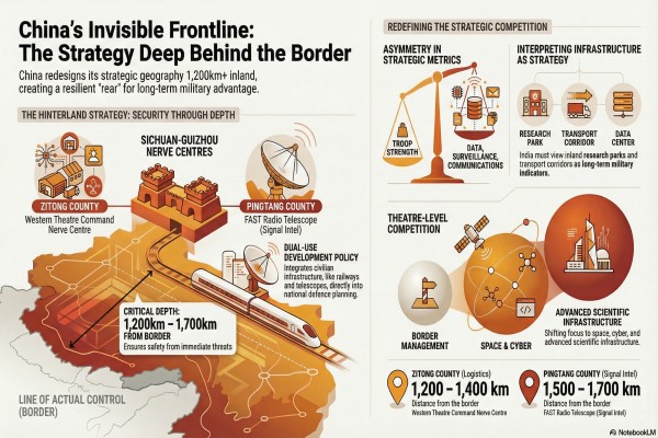
Two little-known counties illustrate this broader shift: Zitong County (Zitong Xian, 梓潼县) in Sichuan Province and Pingtang County (Pingtang Xian, 平塘县) in neighbouring Guizhou Province. Neither features prominently in Indian strategic discussions, yet both sit within a network of facilities and infrastructure that collectively enhance China’s long-term military and technological capacity.
Zitong County lies approximately 160 kilometres northeast of Chengdu, headquarters of China’s Western Theatre Command — the formation directly responsible for operations along the Indian border. Chengdu, the capital of Sichuan, is not simply an administrative centre; it functions as the operational nerve hub for military planning facing India. When specialised facilities, logistics networks, and protected installations expand near such a command centre, they warrant strategic scrutiny rather than dismissal as routine development.
Geography is central to this logic. Zitong lies roughly 1,200–1,400 kilometres from the India–China border — distant enough to remain secure from immediate military threat, yet close enough to support sustained operational logistics. This reflects a classic principle of strategic depth: critical capabilities are positioned beyond frontline vulnerability while remaining integrated within wartime command structures.
Pingtang County presents a different but equally significant case. Located about 1,200 kilometres southeast of Chengdu, it hosts the Five-hundred-meter Aperture Spherical Telescope (FAST), the world’s largest radio telescope. Officially dedicated to astronomical research, FAST embodies China’s scientific prestige. Yet advanced radio telescopes inherently carry dual-use potential, including deep-space tracking, satellite monitoring, and advanced signal analysis.
Pingtang lies approximately 1,500–1,700 kilometres from the Indian border. In an earlier era, such distance might have implied irrelevance. In the age of cyber warfare, satellite navigation, and electronic intelligence, distance no longer limits strategic impact. Information dominance moves instantly.
China’s western development strategy increasingly blends civilian modernisation with strategic resilience. Railways across mountainous terrain, highways linking inland provinces, research facilities in remote regions, and advanced technological installations together form an integrated system supporting national power. Each project may appear civilian in isolation. Viewed collectively, they reflect coordination consistent with long-term military planning.
This is not accidental overlap; it is dual-use development embedded in national policy.
Unlike India, which often separates economic planning from defence policy, China integrates the two. Infrastructure investments serve growth, governance, and security simultaneously. A transport corridor built for commerce can enable rapid military mobilisation. Scientific research strengthens innovation while supporting defence technologies. Regional development reduces inequality while relocating sensitive capabilities to safer inland zones.
The Western Theatre Command benefits significantly from this approach. Rather than relying solely on forward deployments near the border, China is constructing a vast support ecosystem stretching deep into its interior — protected, technologically advanced, and logistically connected.
For India, the implications are significant.
Indian strategic thinking still tends to measure competition through visible indicators: troop strength, artillery positioning, or airfield construction near contested areas. These metrics remain important but are increasingly insufficient. Modern military advantage depends as much on data infrastructure, surveillance networks, communications resilience, and scientific capacity as on tanks or soldiers.
China appears to grasp this shift clearly.
Beijing’s inland investments also reduce vulnerability. Coastal China faces maritime pressure in the Indo-Pacific, particularly from the United States and its allies. By strengthening western provinces, China creates a continental strategic rear — a secure zone capable of sustaining operations even during prolonged crises. Critical facilities in provinces like Sichuan and Guizhou are harder to target and easier to defend.
In effect, China is decentralising strategic capability while maintaining centralised command.
India’s response has largely focused on catching up along the LAC: building border roads, tunnels, advanced landing grounds, and forward logistics nodes. These efforts are essential and long overdue. But parity at the border cannot compensate for asymmetry in strategic depth.
India must widen its perspective from border management to theatre-level competition.
This requires sustained investment in space-based surveillance, electronic intelligence, secure communications networks, and advanced scientific infrastructure with dual-use applications. Civilian technology ecosystems, artificial intelligence research, space science, and telecommunications innovation must be viewed as components of national security rather than purely economic sectors.
Equally important is analytical clarity. India must learn to interpret infrastructure as strategy. Chinese policy documents rarely outline military objectives explicitly; instead, intent emerges through patterns of development over time. Observatories, research parks, and inland logistics corridors may not appear threatening individually, but together they alter the strategic balance.
Ignoring these signals risks repeating past surprises.
China’s rise has not been sudden. It has advanced incrementally, often below the threshold of alarm. Western China today is emerging as a technologically advanced strategic hinterland — resilient, connected, and positioned to support military operations without appearing overtly militarised.
For Indian policymakers, analysts, and the wider public, the lesson is clear, if uncomfortable: strategic competition with China will not always announce itself through confrontation. More often, it will arrive disguised as development.
Beijing is building patiently in places few Indians can locate on a map. Yet the capabilities emerging there will shape the security environment along India’s borders for decades.
India must therefore widen its strategic gaze. The real question is no longer what China is doing at the frontier, but what it is preparing far behind it—and whether India is prepared to think just as far ahead.


