


In this new series Disputed, we look at those sections of the India China boundary that could be potentially more easy to resolve. We begin with Barahoti in the Middle Sector, which, along with Sikkim, could comprise the “early harvest” the Chinese have talked about. The facts and arguments cited here are based on Defence Ministry records.
The Barahoti grazing grounds in Uttarakhand’s Chamoli district, is at a height of 14,000 feet. The area is as remote as it is picturesque. No proposals have been made by India or China on resolving this dispute since the nor is there as yet any schedule for talks.
According to the Indian Defence Ministry, Barahoti is one of the first disputed areas along the India-China boundary. That situation arose in 1955 when India sent police patrols to Barahoti to establish the precise location of Tunjun La, a pass leading into Tibet.
The Chinese objected, lodged protests and sent their own personnel into Barahoti, leading India to protest. Later that year, China set up a camp in Barahoti naming that area as “Wu Je” and that it belonged to Tibet.
But were the Chinese entirely clear about where Barahoti was? The Chinese counsellor in India claimed it was 12 km north of the Tunjun La when actually it is south of it.
In June 1956, the Chinese suggested both sides refrain from sending troops into Barahoti until a diplomatic settlement was arrived at. This was along roughly similar lines to an Indian proposal to “neutralise” the area made the previous year.
In 1957 no forces were sent by either side although protest notes continued to be exchanged culminating in a conference in Delhi in April 1958. The two sides agreed on not sending any armed personnel into Barahoti but the Chinese said civilian personnel should be allowed.
Since then that practice has continued but some disturbing signals: China’s claim about the size of Barahoti changed, from 150 sq. km to 776 sq. km voiced at the border talks in 1960. This was done by claiming, for the first time, that Barahoti included two areas Sangcha Malla and Lapthal lying to the south.
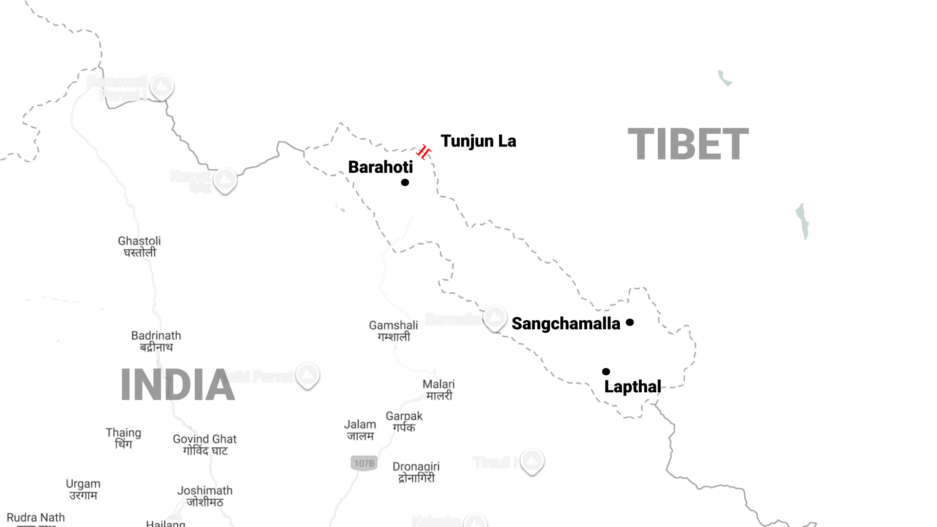
In India’s view, the area under dispute is no more than 80 sq. km. China’s claim therefore is exaggerated, giving the impression it is seeking to build leverage.
The Chinese claims only underscored a major Indian problem, the difficulties in physically dominating Barahoti which involved crossing the Chorhoti Pass at an altitude of more than 21,300 feet. But a physical presence was required so Capt. Narinder Kumar (later colonel), was tasked with the job.
By April 1961 he had established an all-weather post at Rimkhin, which is just short of the ridge line that descends into the Barahoti bowl. Five months later the post was shut down after experiencing difficulties with maintaining supplies during the winter. The post was re-established in April 1962 with a platoon strength of troops (about 30 men).
The Chinese promptly responded by sending troops at regular intervals into the Barahoti area, reportedly deploying around five battalions and laying tracks from Tholing to the Indian border, a distance of roughly 15 km at the nearest point.
The ground situation did not escalate during the 1962 war. After the war, Barahoti was “demilitarised by mutual agreement”, thereby giving credence to the terminology of Demilitarized Zone.
In 1995, Barahoti was accepted as one of the eight “Mutually Agreed Disputed Areas” by both sides during the Expert Group meeting. IN 2000-2001, during the exchange of Middle Sector maps, about 378 sq. km of area difference had emerged in respective LAC perceptions.
China maintains that Barahoti is under the jurisdiction of Dapa Dzong district of Tibet and claims approximately 740 sq. km of Indian territory in this area.
Thus even today, Barahoti remains a potential flash point in the Middle Sector. Opposite the Barahoti Bowl, the major Chinese garrison is located at Thoiing and other minor deployments are at Poling and Dapa Dzong.
The Chinese road communications in this area is also well developed with natural surface roads coming up to the Mana Pass, Niti Pass and Tunjun La that are right on the boundary. As the area is served with specific road arteries surrounded by mountains, it is of utmost importance to defend these road axes against any Chinese aggression.
Hence the concept of defending all the axes by holding defences in tiered form holds merit and forms the fundamentals of the defence of Barahoti.


