


The Shaksgam Valley in Pakistan Occupied Kashmir, was recently in the news following reports that China’s road building efforts have now brought it to within 48 km of the northern part of the Siachen Glacier. The glacier has been held by India since 1984 and the closer the Chinese come, the greater India’s concern. The Shaksgam Valley was handed over by Pakistan to China in 1963, an act which India regards as illegal since this is Indian territory. This essay aims to provide a rudimentary analysis to elucidate the situation in the Shaksgam Valley and its implications for India’s strategic calculations.
Geography:
The Shaksgam Valley measures around 5,163-sq km. Bearing the same name is the Shaksgam River, a tributary of the Yarkand River, boasting a greater number of glaciers feeding it compared to the headstream of the Yarkand. Situated between the western Karakorams, traditionally dominated by the Hunza of Kashmir, and the Kun Lun Range, serving the frontiers of Khotan, the Shaksgam Valley essentially constitutes no man’s land. Positioned just south of the Aghil Range, a minor mountain range nestled within the Trans Karakoram region between the imposing Kunlun and Karakoram ranges, Shaksgam holds strategic significance.
Access to the Shaksgam Valley primarily involves four major routes: three from the Xinjiang side and one from across the Karakorams. The most accessible route, originating from the west, entails traversing along the river upstream. Another significant route lies to the north, crossing the Aghil Pass through the Aghil Range, facilitating access to the northern approach of the K2. Historically, caravans utilized a trail across Aghil Pass to access the Shaksgam Valley, navigating through lesser-traveled paths. The third route deemed the most challenging, traverses westward, delineating the watershed between Yarkand and Shaksgam rivers, known as the Shaksgam Pass. Fourth, the southern approach across the Shimshal Pass, situated in Hunza of Pakistan-occupied Gilgit Baltistan, remains the most renowned route to the valley.
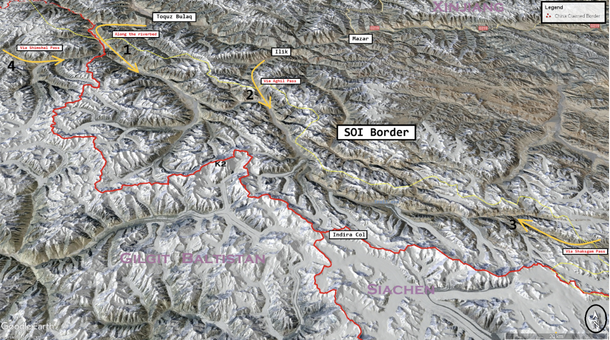
Minor routes also exist, such as Marpo Pass near Shaksgam Pass. Then there is one that originates from the Siachen Glacier, traversing Indira Col before descending to Shaksgam Valley via the Urdok Glacier. The other route leads via Muztagh Pass, touted by Pakistan as an alternative to the existing China-Pakistan Economic Corridor (CPEC). Pakistan proposed that this route would span from Xinjiang through Shaksgam, Muztagh Pass, Askole, Shigar, Skardu, and the Deosai Plateau, ultimately entering Pakistan-occupied Kashmir (POK) through the Neelum Valley.
History:
Historically, the Shaksgam Valley has been deemed uninhabitable due to its remote location and harsh living conditions. It served as a route for caravan trails during the summer months, witnessing occasional human activity. Given its position on the fringes of Kashmir and Khotan, various entities, including the Mir of Hunza, laid claim to it.
In modern times, the first European expedition to the Shaksgam Valley was led by Francis Younghusband in 1889. Subsequent diplomatic efforts by the British aimed to establish formal boundaries between Qing China and British India. However, Qing China did not respond. It is understood that the proposed borders were influenced by geopolitical concerns, particularly the Great Game. Britain sought to expand a buffer zone north of the Shaksgam River, partly in response to fears of Russian expansion amidst Qing China’s weakening state.
During British rule, maps depicted varying representations of the border, leaving the status of the Shaksgam Valley contentious. Following independence and the loss of the Gilgit Agency, India lost its sole physical access to the Valley. In 1959, as Chinese maps began illustrating areas within Gilgit, then under Pakistan’s control, Pakistan reciprocated by claiming territory up to the Kun Lun Range.

Subsequently, negotiations between Pakistan and the People’s Republic of China (PRC) commenced in 1962, resulting in the Sino-Pakistan Frontier Agreement of 1963. Under this agreement, Pakistan recognized Chinese sovereignty over the Shaksgam Tract, sparking controversy, particularly in India. Prime Minister Jawaharlal Nehru expressed concern over what he perceived as Pakistan’s surrender of Indian territory to China, as maps indicated the cession of significant areas historically claimed by Kashmir of India.
Developments:
After the agreement, little attention was paid to the distant, barely connected, remote frontier, which essentially constituted a newly acquired and somewhat troublesome province of Xinjiang for the PRC. It was primarily utilized by locals, who, during the summer months, wandered through the upper reaches via camels crossing the Aghil Pass from the North, accompanying adventurous mountaineers seeking rare views and access to K2 and the Gasherbrum group from the northern side. As all the famous Karakoram peaks were also accessible via the Shaksgam Valley, this pattern continued until recent times.
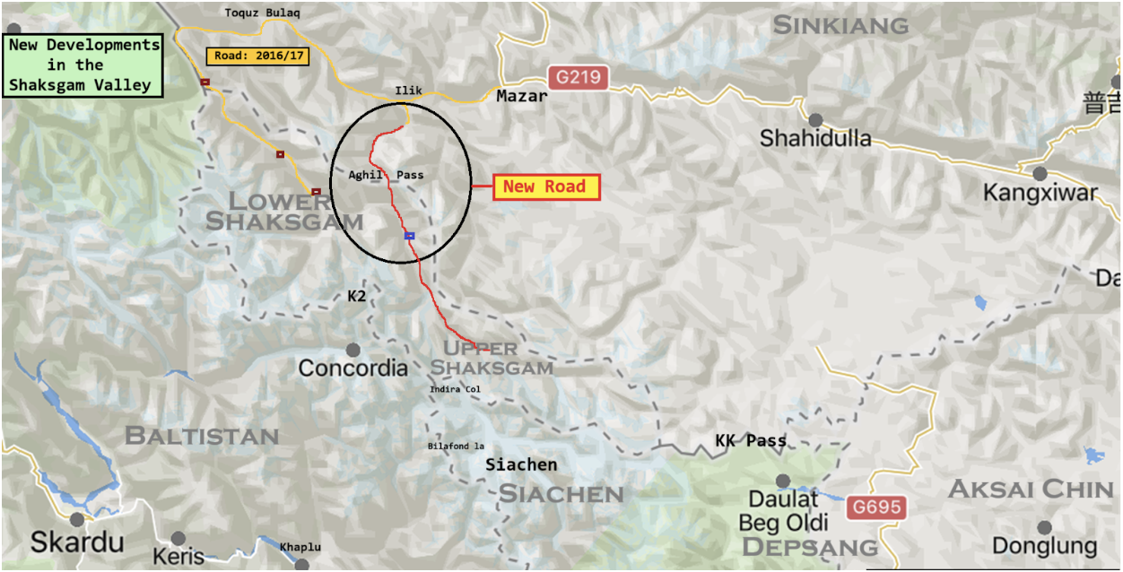
Then, in the second half of the last decade, as the Chinese growth story reached its peak and connectivity to frontier areas gained new momentum, a road was constructed in the Shaksgam Valley. This new road aimed to provide access to the valley via an easier route along the riverbed upstream from the areas of Raksam, thus shortening the trek for mountaineers. At first glance, the new road appeared unrelated to any provocation or signaling amidst the Doklam standoff but rather a practical solution for the Chinese, who considered it their own. They established a border guards outpost at the confluence of the Shaksgam and Yarkand rivers, along with a few pickets along the newly built road, to monitor activities in the valley along the road.
Years later, permanent settlements were established near Ilik and Toquz Bulaq for the nomadic communities enduring those harsh conditions. Last year, an initiative to revive the ancient Aghil Pass camel trail was undertaken, resulting in the operationalization of a second access route. A rudimentary trail was carved across the Aghil Pass, allowing the road to directly reach the Shaksgam Valley from Ilik. Currently, it remains a basic motorable trail under construction, retracing the ancient route. As of May 2024, the road has extended to 35.74119° N, 76.96928° E, at the base of the Singhi glacier, and it appears unlikely to ascend further from there. This suggests that the vision behind constructing the road is to revive the ancient trail and facilitate easier access to the glaciers of the upper Shaksgam Valley for tourists and researchers. As of May 2024, two camps supporting the road construction at 36.06099° N, 76.67173° E, and 35.82451° N, 76.77724° E are visible.
Observations and Implications:
The new motorable trail is indeed situated too close to the northern reaches of the Siachen Glacier, particularly Indira Col, but there are no indications of its use for militarizing the upper Shaksgam Valley. No activity supporting the alternative to the CPEC via Muztagh Pass has been observed. In the future, this trail might be connected to areas opposite Indian positions in Sub Sector North (SSN) via Shaksgam Pass, linking to a recently constructed road reaching the source of the Yarkand River. This newer motorable trail from Ilik is linked to Mazar, a pit stop along the G219 highway, and complements the earlier road along the Shaksgam riverbed, easily accessible via Raksam and Taskargun. It is prudent to monitor developments in the occupied Shaksgam Valley due to its strategic significance in the broader context of Sino-Indian relations and future boundary settlement negotiations.


